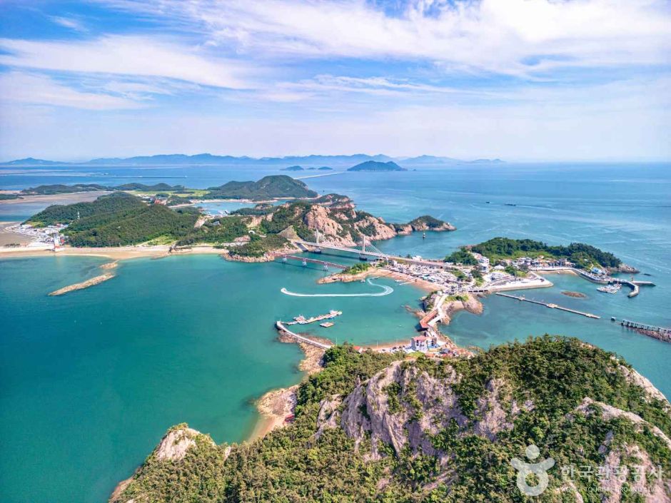
It is linked to Jangjado Island by the 33 m Daejang Bridge. On the island there is an exhibition of bonsai and viewing stones that one person collected over decades. Cormorant Island, a small rock island to the northeast, is home to cormorants and Eurasian oystercatchers, Natural Monument No. 326.
Source: Korea Tourism Organization · KOGL Type 1 · 7 photos
Daejangdo Island The sea today
Nov 4 (Wed)
Open at all times
Tides
Nearest station · 8.0 km away
Tides · Nov 4 (Wed)
Tide
Time
Height
Low tide
05:15
196 cm
High tide
11:00
469 cm
Low tide
17:32
173 cm
High tide
23:40
526 cm
Shown for seaside places only, when the nearest tide station is within 30 km in a straight line. The curve joins the times and heights of high and low tide.
Tourist information in Gunsan: 8 tourist information centers, free tours by culture and tourism guides and the 47-point Gunsan stamp tour, with hours, departure times and completion rules
Daejangdo Island in detail
The 33 m Daejang Bridge links Daejangdo Island and Jangjado Island; Seonyudo Island is a 30-minute walk
Daejangdo Island is linked to Jangjado Island by the 33 m Daejang Bridge. Bridges continue past Jangjado Island to Seonyudo Island, so you can walk or cycle among the three islands. According to Gunsan City, the walk from Daejangdo Island to Seonyudo Island takes about 30 minutes. By road, take the Gunsan–Jeonju expressway (toward Gunsan), then pass Bieungdo Island, Yamido Island, Sinsido Island, Munyeodo Island, Seonyudo Island, and Jangjado Island in order to reach Daejangdo Island.
Jangja Halmae Rock on Daejangdo Island: the legend of a wife turned to stone with her baby on her back
Jangja Grandmother Rock on Daejangdo Island is still often seen wrapped in straw rope or white cloth. A legend tells of a wife who waited on Sanmaru for her husband, who had gone to Seoul to take the state examination. He came back without passing, bringing a new wife and son. She turned away and became stone along with the child on her back. There is also a story that a couple's promise of love made in front of this rock will come true.
Cormorant Island, northeast of Daejangdo Island: a habitat for Eurasian oystercatchers (Natural Monument No. 326) and cormorants
Cormorant Island, a small rock island northeast of Daejangdo Island, is a habitat for Eurasian oystercatchers and cormorants. The Eurasian oystercatcher is a rare bird designated as Natural Monument No. 326.
Can you walk from Daejangdo Island to Seonyudo Island?
Yes, and it takes about 30 minutes. Daejangdo Island is linked to Jangjado Island and Seonyudo Island by bridges, so you can walk or cycle between them. source 1
Can you get to Daejangdo Island without taking a boat?
Yes, by road. From the Gunsan–Jeonju expressway (toward Gunsan), pass Bieungdo Island, Yamido Island, Sinsido Island, Munyeodo Island, Seonyudo Island, and Jangjado Island in order to reach Daejangdo Island. source 1
Can I park at Daejangdo Island?
No, you cannot park there. The island is always open, all year. source 2
Where can you watch the sunrise and sunset on Daejangdo Island?
You can see both the sunrise and the sunset from the hill in front of the bridge to Jangjado Island. source 1
What is the legend of Jangja Halmae Rock on Daejangdo Island?
It is the legend of a wife who turned to stone with her baby on her back while waiting for her husband, who had left to take the civil service exam. When he came back without passing, bringing a new wife and a son, she turned away and hardened into stone on the spot. source 1
Where does the name Daejangdo Island come from?
A story says that a Taoist sage told the islanders a large, long bridge would one day be built to the island and then vanished. The residents believed him and called the island Daejangdo Island. Today the 33 m Daejang Bridge stands between Jangjado Island and Daejangdo Island. source 1
What birds live near Daejangdo Island?
Cormorant Island, a small rock island to the northeast, is a habitat for cormorants and Eurasian oystercatchers (Natural Monument No. 326). source 1
How long is the Daejang Bridge on Daejangdo Island?
It is 33 m long. The Daejang Bridge links Jangjado Island and Daejangdo Island. From Daejangdo Island you can walk or cycle along the bridges through Jangjado Island to Seonyudo Island. source 1
What local food does Daejangdo Island have?
There is sand lance fish sauce. It is made from sand lance caught off the West Sea and aged in the sea breeze. source 1
What can you see on Daejangdo Island?
There is an exhibition of bonsai and viewing stones that one person collected over decades. There is also Jangja Grandmother Rock, tied to the legend of a wife who turned to stone, and Cormorant Island to the northeast, where Eurasian oystercatchers and cormorants live. source 1




 Daejangbong Observatorystraight-line 60 m
 Daejangbong Peakstraight-line 80 m
 Jangjado Wharfstraight-line 890 m


 Cafe La Pharestraight-line 620 m
 Namdo Bapsangstraight-line 1.8 km

